Google Earth Engine ——全球人类住区层(GHSL)数据集
Google Earth Engine ——全球人类住区层(GHSL)数据集

The GHSL relies on the design and implementation of new spatial data mining technologies allowing to automatically process and extract analytics and knowledge from large amount of heterogeneous data including: global, fine-scale satellite image data streams, census data, and crowd sources or volunteered geographic information sources.
These data contain a multitemporal information layer on built-up presence as derived from Landsat image collections (GLS1975, GLS1990, GLS2000, and ad-hoc Landsat 8 collection 2013/2014).
The data have been produced by means of Global Human Settlement Layer methodology in 2015.
For more information visit: Global Human Settlement - GHS BUILT-UP GRID - European Commission and https://ghsl.jrc.ec.europa.eu/documents/GHSL_data_access.pdf.
The Global Human Settlement Layer (GHSL) project is supported by the European Commission, Joint Research Center, and Directorate-General for Regional and Urban Policy. The GHSL produces new global spatial information, evidence-based analytics, and knowledge describing the human presence in the planet.
GHSL依赖于新的空间数据挖掘技术的设计和实施,允许自动处理并从大量的异质数据中提取分析结果和知识,这些数据包括:全球精细的卫星图像数据流、人口普查数据以及人群来源或自愿的地理信息来源。
这些数据包含了从Landsat图像集(GLS1975、GLS1990、GLS2000和2013/2014年特设的Landsat 8图像集)得出的关于建筑存在的多时空信息层。
这些数据是在2015年通过全球人类住区层方法产生的。
欲了解更多信息,请访问。 全球人类住区 - GHS BUILT-UP GRID - 欧盟委员会和https://ghsl.jrc.ec.europa.eu/documents/GHSL_data_access.pdf。
全球人类住区层(GHSL)项目由欧盟委员会、联合研究中心和区域与城市政策总局支持。GHSL产生新的全球空间信息、基于证据的分析和描述人类在地球上存在的知识。
Dataset Availability
1975-01-01T00:00:00 - 2014-12-31T00:00:00
Dataset Provider
Collection Snippet
ee.Image("JRC/GHSL/P2016/BUILT_LDSMT_GLOBE_V1")
Resolution
38 meters
Bands Table
Name | Description | Min | Max |
|---|---|---|---|
built | Multitemporal built-up presence | ||
cnfd | Gaps-filled confidence grid on the built-up class aggregated for 2014. 0 = 100% confidence of no built-up, 127 = 50% decision cut off, 255 = 100% conficence of yes built-up | 0 | 255 |
dm | Mosaic of data availability in the different epochs. |
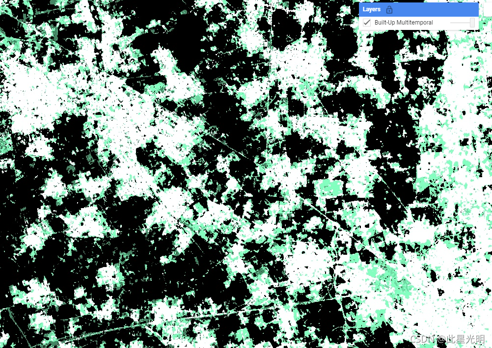
Class Table: built
Value | Color | Color Value | Description |
|---|---|---|---|
1 | #0c1d60 | Water surface | |
2 | #000000 | Land no built-up in any epoch | |
3 | #448564 | Built-up from 2000 to 2014 epochs | |
4 | #70daa4 | Built-up from 1990 to 2000 epochs | |
5 | #83ffbf | Built-up from 1975 to 1990 epochs | |
6 | #ffffff | built-up up to 1975 epoch |
Class Table: dm
Value | Color | Color Value | Description |
|---|---|---|---|
1 | # | No data availability for any epoch | |
2 | # | 1975 | |
3 | # | 1990 | |
4 | # | 1975 and 1990 | |
5 | # | 2000 | |
6 | # | 1975 and 2000 | |
7 | # | 1990 and 2000 | |
8 | # | 1975, 1990, and 2000 | |
9 | # | 2015 | |
10 | # | 1975 and 2015 | |
11 | # | 1990 and 2015 | |
12 | # | 1975, 1990, and 2015 | |
13 | # | 2000 and 2015 | |
14 | # | 1975, 2000, and 2015 | |
15 | # | 1990, 2000. and 2015 | |
16 | # | 1995, 1190, 2000, and 2015 |
数据说明和引用:
The GHSL has been produced by the EC JRC as open and free data. Reuse is authorised, provided the source is acknowledged. For more information, please read the use conditions (European Commission Reuse and Copyright Notice).
Pesaresi, Martino; Ehrilch, Daniele; Florczyk, Aneta J.; Freire, Sergio; Julea, Andreea; Kemper, Thomas; Soille, Pierre; Syrris, Vasileios (2015): GHS built-up grid, derived from Landsat, multitemporal (1975, 1990, 2000, 2014). European Commission, Joint Research Centre (JRC) [Dataset] PID: Joint Research Centre Data Catalogue - GHS-BUILT R2015B - GHS built-up grid, derived from... - European Commission
Pesaresi, Martino; Ehrlich, Daniele; Florczyk, Aneta J.; Freire, Sergio; Julea, Andreea; Kemper, Thomas; Soille, Pierre; Syrris, Vasileios (2015): GHS built-up confidence grid, derived from Landsat, multitemporal (1975, 1990, 2000, 2014). European Commission, Joint Research Centre (JRC) [Dataset] PID: Joint Research Centre Data Catalogue - GHS-BUILT R2015B - GHS built-up confidence grid, d... - European Commission
Pesaresi, Martino; Ehrlich, Daniele; Florczyk, Aneta J.; Freire, Sergio; Julea, Andreea; Kemper, Thomas; Soille, Pierre; Syrris, Vasileios (2015): GHS built-up datamask grid derived from Landsat, multitemporal (1975, 1990, 2000, 2014). European Commission, Joint Research Centre (JRC) [Dataset] PID: Joint Research Centre Data Catalogue - GHS-BUILT R2015B - GHS built-up datamask grid, der... - European Commission
代码:
????var dataset = ee.Image('JRC/GHSL/P2016/BUILT_LDSMT_GLOBE_V1');
var builtUpMultitemporal = dataset.select('built');
var visParams = {
  min: 1.0,
  max: 6.0,
  palette: ['0c1d60', '000000', '448564', '70daa4', '83ffbf', 'ffffff'],
};
Map.setCenter(8.9957, 45.5718, 12);
Map.addLayer(builtUpMultitemporal, visParams, 'Built-Up Multitemporal');