NASA数据集——2018-2024年VIIRS/NOAA20 深蓝 3 级每日气溶胶数据,1x1 度网格
NASA数据集——2018-2024年VIIRS/NOAA20 深蓝 3 级每日气溶胶数据,1x1 度网格

VIIRS/NOAA20 Deep Blue Level 3 daily aerosol data, 1 degree x 1 degree grid
简介
联合极地卫星系统(JPSS)系列 NOAA-20 仪器的可见红外成像辐射计套件(VIIRS)NASA 标准三级(L3)每日深蓝气溶胶产品提供了全球陆地和海洋上空气溶胶光学厚度(AOT)的卫星衍生测量数据及其网格集合属性。深蓝算法借鉴了以前从陆地和海洋上的海洋观测宽视场传感器(SeaWiFS)和陆地上的中分辨率成像分光仪(MODIS)测量中获取气溶胶光学厚度的应用。这一每日汇总产品(简称:AERDB_D3_VIIRS_NOAA20)源自基于第 2.0 版(V2.0)L2 6 分钟扫描带的产品(AERDB_L2_VIIRS_NOAA20),以 1 x 1 度的水平分辨率网格提供。在大多数情况下,每个数据字段表示所有单元的算术平均值,这些单元的经纬度坐标位于每个网格元素的边界范围内。此外,还提供标准偏差等其他测量方法。该汇总产品仅使用经过质量保证过滤的最佳估计检索结果。该算法仅使用在相关日期测量到的单元格,要求至少有三次检索到的测量结果才能使给定网格在任何给定日期都有效。该每日产品记录始于 2018 年 2 月 17 日。
该 L3 每日产品采用 netCDF 格式,包含 45 个科学数据集 (SDS) 图层,其中包括以下内容:
- Aerosol_Optical_Thickness_550_Land_Count
- Aerosol_Optical_Thickness_550_Land_Maximum
- Aerosol_Optical_Thickness_550_Land_Mean
- Aerosol_Optical_Thickness_550_Land_Minimum
- Aerosol_Optical_Thickness_550_Land_Ocean_Count
- Aerosol_Optical_Thickness_550_Land_Ocean_Maximum
- Aerosol_Optical_Thickness_550_Land_Ocean_Mean
- Aerosol_Optical_Thickness_550_Land_Ocean_Minimum
- Aerosol_Optical_Thickness_550_Land_Ocean_Standard_Deviation
- Aerosol_Optical_Thickness_550_Land_Standard_Deviation
- Aerosol_Optical_Thickness_550_Ocean_Count
- Aerosol_Optical_Thickness_550_Ocean_Maximum
- Aerosol_Optical_Thickness_550_Ocean_Mean
- Aerosol_Optical_Thickness_550_Ocean_Minimum
- Aerosol_Optical_Thickness_550_Ocean_Standard_Deviation
- Aerosol_Type_Land_Ocean_Histogram
- Aerosol_Type_Land_Ocean_Mode
- Aerosol_Types
- Angstrom_Exponent_Land_Maximum
- Angstrom_Exponent_Land_Mean
- Angstrom_Exponent_Land_Minimum
- Angstrom_Exponent_Land_Ocean_Maximum
- Angstrom_Exponent_Land_Ocean_Mean
- Angstrom_Exponent_Land_Ocean_Minimum
- Angstrom_Exponent_Land_Ocean_Standard_Deviation
- Angstrom_Exponent_Land_Standard_Deviation
- Angstrom_Exponent_Ocean_Maximum
- Angstrom_Exponent_Ocean_Mean
- Angstrom_Exponent_Ocean_Minimum
- Angstrom_Exponent_Ocean_Standard_Deviation
- Fine_Mode_Fraction_550_Ocean_Mean
- Fine_Mode_Fraction_550_Ocean_Standard_Deviation
- Land_Bands
- Latitude
- Latitude_1D
- Longitude
- Longitude_1D
- Ocean_Bands
- Spectral_Aerosol_Optical_Thickness_Land_Count
- Spectral_Aerosol_Optical_Thickness_Land_Mean
- Spectral_Aerosol_Optical_Thickness_Land_Standard_Deviation
- Spectral_Aerosol_Optical_Thickness_Ocean_Count
- Spectral_Aerosol_Optical_Thickness_Ocean_Mean
- Spectral_Aerosol_Optical_Thickness_Ocean_Standard_Deviation
- Unsuitable_Pixel_Fraction_Land_Ocean
有关全局属性、数据字段属性、质量标志、处理和使用这些数据产品的软件等更多信息,请查阅 VIIRS 深蓝气溶胶产品用户指南。
数据信息
Shortname: | AERDB_D3_VIIRS_NOAA20 |
|---|---|
Platform: | NOAA-20 |
Instrument: | VIIRS |
Processing Level: | Level-3 |
Data Format: | netCDF4 |
Spatial Resolution: | 1 degree |
Temporal Resolution: | daily |
ArchiveSets: | 5200 |
Collection: | NPP and JPSS1 VIIRS data 2.0 (ArchiveSet 5200) |
PGE Number: | NONE |
File Naming Convention: | Syntax: ESDT.AYYYYDDD.CCC.YYYYDDDHHMMSS.Format Example: AERDB_D3_VIIRS_NOAA20.A2020001.002.2022245184551.nc ESDT Earth Science Data Type or ShortnameA Stands for AcquisitionYYYYDDD Data acquisition year and Day-of-year per the Julian CalendarCCC Version ID of the data collectionYYYYDDDHHMMSS Processing year, Day-of-year, UTC time (hour, minutes, seconds)Format File format suffix, which in the above case represents netCDF4 |
Keywords: | NOAA20 VIIRS, L3, Daily Aggregated, Deep Blue Aerosol Optical Thickness |
- ESDT Earth Science Data Type or Shortname
- A Stands for Acquisition
- YYYYDDD Data acquisition year and Day-of-year per the Julian Calendar
- CCC Version ID of the data collection
- YYYYDDDHHMMSS Processing year, Day-of-year, UTC time (hour, minutes, seconds)
- Format File format suffix, which in the above case represents netCDF4
Keywords:NOAA20 VIIRS, L3, Daily Aggregated, Deep Blue Aerosol Optical Thickness
代码
!pip install leafmap
!pip install pandas
!pip install folium
!pip install matplotlib
!pip install mapclassify

import pandas as pd
import leafmap

url = "https://github.com/opengeos/NASA-Earth-Data/raw/main/nasa_earth_data.tsv"
df = pd.read_csv(url, sep="\t")
df

leafmap.nasa_data_login()


results, gdf = leafmap.nasa_data_search(
    short_name="AERDB_D3_VIIRS_NOAA20",
    cloud_hosted=True,
    bounding_box=(-180.0, -90.0, 180.0, 90.0),
    temporal=("2018-01-05", "2024-02-10"),
    count=-1,  # use -1 to return all datasets
    return_gdf=True,
)


gdf.explore()

#leafmap.nasa_data_download(results[:5], out_dir="data")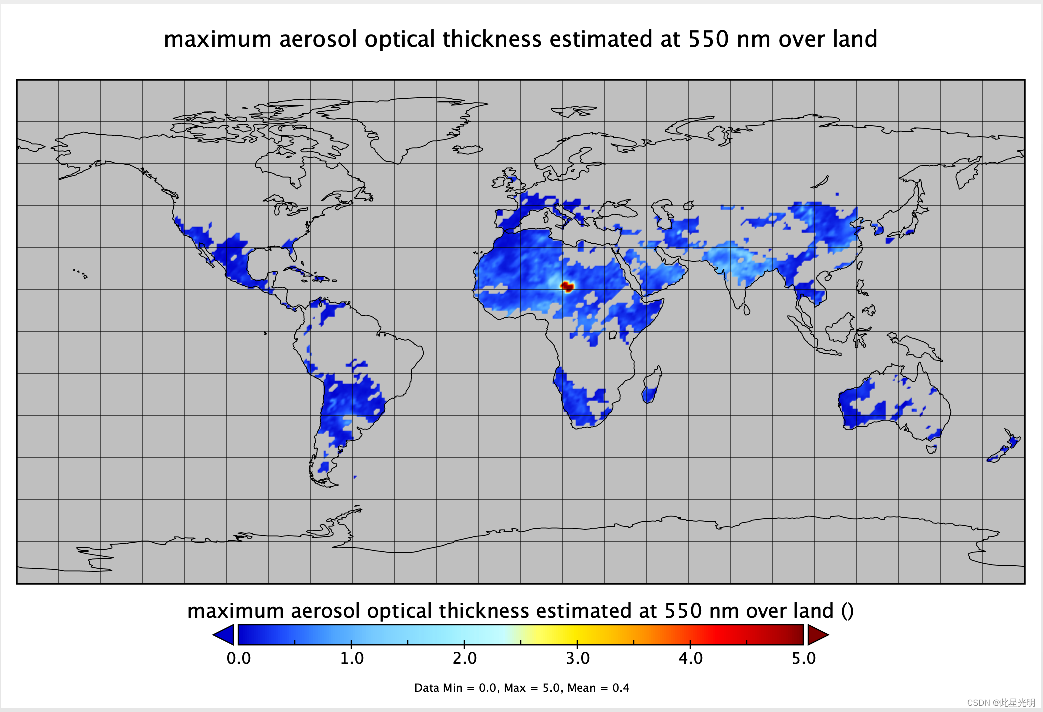
引用
doi.org/10.5067/VIIRS/AERDB_D3_VIIRS_NOAA20.002
网址推荐
0代码在线构建地图应用
https://sso.mapmost.com/#/login?source_inviter=nClSZANO